- 24 Jun, 2026
 and Mass Rapid Transit (MRT) of Singapore")
Managing traffic and transporting large numbers of people daily becomes an enormous task for urban cities. Whereas other Western cities are faced with issues like dilapidated train lines, reduced passenger numbers, and limited budgets, Singapore has created one of the most effective systems across the globe. The country relies heavily on its — Mass Rapid Transit (MRT) and Light Rail Transit (LRT) systems — to ensure smooth travel for everyone. The MRT system of the country is renowned worldwide for its hyper-efficiency, cleanliness, and seamless connectivity.
The railway transportation system in Singapore is administered in collaboration between LTA (Land Transport Authority) and other transit companies such as SMRT and SBS Transit. Everything fits in well since both lay plans for trains as well as the houses in the city. These air conditioned trains will transport you straightaway from Changi Airport right through to the shopping centers, tourist attractions, and historical sites.
Major Distinction Between MRT and LRT in Singapore:
|
Feature |
MRT (Mass Rapid Transit) |
LRT (Light Rail Transit) |
|
System Role |
Main trunk network connecting the whole island. |
Feeder network within specific neighborhoods. |
|
Train Capacity |
High (3 to 6 large carriages per train). |
Low (1 to 2 smaller carriages per train). |
|
Coverage Area |
Major towns, city center, and commercial hubs. |
Local residential estates (Bukit Panjang, Sengkang, Punggol). |
|
Track Structure |
Underground, street-level, or elevated viaducts. |
Exclusively elevated tracks weaving through estates. |
|
Speed |
Faster, with longer distances between stations. |
Slower, making frequent stops closer together. |
Important Facts and Numbers at a Glance
The public transport system in Singapore is designed in such a way that it carries thousands of people each day on the island. As there are measures of tracking the number of passengers all the time, adjustments of the train schedules can be made.
|
Singapore MRT and LRT Network in Numbers |
|
|
Feature |
Quick Detail |
|
Daily MRT Rides |
3.49 Million Trips Each Day |
|
Daily LRT Rides |
209,000 Trips Each Day |
|
Total Track Length |
269.5 Kilometers (Fully Expanded) |
|
Interchange Hubs |
Over 30 Stations Linking Multiple Lines |
|
Rush Hour Waiting |
Trains Arrive Every 2 to 3 Minutes |
|
Normal Waiting Time |
Trains Arrive Every 5 to 7 Minutes |
According to recent data, daily MRT rides grew to 3.49 million. At the same time, fewer people used the smaller LRT trains. This happened because the government added direct walkways and more major bus routes, which means passengers can now skip the smaller neighborhood trains entirely.
How the Train System Grew Over Time in Singapore
We have broken down the timeline into five distinct eras:
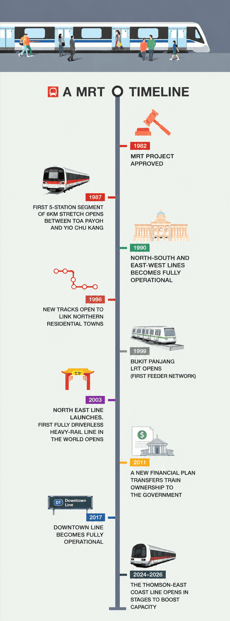
- Planning Era (1967-1982): Planners argued on whether to have an all bus-network or rail-based system. The government selected the latter to avoid future traffic congestion.
- Establishing the Foundations (1987-1995): The very first short track opened in 1987. By 1990, the main North-South and East-West train lines were running to take people from their homes to where they work.
- Going Driverless (1996-2010): Small neighborhood loop trains started running in 1999. In 2003, the North East Line became the first big underground train line in the world to move completely by itself without a driver.
- Deeper Subways (2011-2025): The Downtown and Thomson-East Coast lines were constructed underground by workers connecting the north, east, and west suburban areas to the city. The system grew, and as time passed and the older tracks aged, there was an increased number of delays between 2011 and 2015. To fix this, the government introduced the New Rail Financing Framework (NRFF). Originally, private companies owned and repaired all the trains. This old model caused issues because upgrading expensive equipment cut into corporate profits. Under the new NRFF system, the government took over the ownership of the tracks and trains. This gave the government an opportunity to undertake extensive improvements in a timely manner while the private corporations concentrated on the operational aspects of their work.
- Future Network (2026 onwards): Construction of the Jurong Region Line and Cross Island Line seeks to ensure that 80% of all households have a station within walking distance within 10 minutes.
Complete Guide to Singapore Rail Lines
The rail system in Singapore features six primary MRT trunk lines, three localized LRT feeder loops, and several major expansions currently under construction. Because every line uses a unique color, two-letter abbreviation, and station numbering system, finding your way around the island is incredibly smooth and easy.
Operating Hours
- Daily Schedule: Trains typically operate from 5:30 AM to midnight daily.
- Peak Hours: High-frequency service runs from 7:00 AM to 9:00 AM and 5:00 PM to 7:00 PM.
Major Operational MRT Lines
These are the major operational MRT lines in Singapore: East West Line (EW – Green), North South Line (NS – Red), North East Line (NE – Purple), Circle Line (CC – Yellow), Downtown Line (DT – Blue) and Thomson-East Coast Line. More information about each of these MRT lines is provided below.
1. East West Line (EW — Green)
-
Length: 57 km
- Number of stations: 35
- Number of interchange stations: 9
This is the longest operating train line in Singapore and stretches all the way through the island starting from its far eastern side to its western industrial areas. This train line acts as the main entrance point for international visitors into the city-state of Singapore.
- Changi Airport (EW24): Connects Terminals 2 and 3 with the rail system. It also has an indoor bridge walkway linking it to the Jewel Changi Airport.
- Bugis (EW12): Allows passengers direct access to the old-world Bugis Street Market and the trendy boutiques found in Haji Lane.
- City Hall (EW13 / NS25): Major downtown interchange hub that is located near the National Gallery of Singapore and St. Andrew’s Cathedral.
- Raffles Place (EW14 / NS26): The heart of Singapore's Central Business District and a short walk from the Singapore River and Merlion Park.
- Outram Park (EW16 / NE3 / TE17): An important junction located on the edge of the historic Chinatown conservation zone.
- Jurong East (EW24 / NS1): The largest transport hub in western Singapore, serving JEM, Westgate, IMM, and the emerging Jurong Lake District.
2. North South Line (NS — Red)
-
Length: 45 km
- Number of stations: 27
- Number of interchange stations: 8
This foundational line is shaped like an inverted "U". It links the northern residential heartlands straight to the central business and shopping districts.
- Orchard (NS22 / TE14): Drops you right below Singapore’s top shopping street, linking through the subway tunnels to ION Orchard and Ngee Ann City.
- Woodlands (NS9 / TE2): Major northern interchange serving the Woodlands Regional Centre and the Singapore–Malaysia border area.
- Dhoby Ghaut (NS24 / NE6 / CC1): A very big multi-line station that gives you direct access to Plaza Singapura and Istana park gardens.
- Newton (NS32 / DT11): The nearest train station to the Newton Food Centre, which is an outdoor hawker center that specializes in the local cuisine such as chilli crab and satay.
- Marina Bay (NS27 / CE2 / TE20): It is situated close to the central financial district of Singapore and connects easily to the Marina Bay Financial Center.
3. North East Line (NE — Purple)
-
Length: 22 km
- Number of stations: 17
- Number of interchange stations: 6
This fully automated underground line runs from the southern waterfront up to the northeastern residential communities. It is highly popular among tourists because it stops at several historical ethnic enclaves.
- HarbourFront (NE1 / CC29): The southern terminal station. It links directly into VivoCity mall, which houses the monorail station and boardwalk leading across to Sentosa Island.
- Chinatown (NE4 / DT19): Steps away from the Buddha Tooth Relic Temple, Sri Mariamman Temple, and bustling street markets.
- Little India (NE7 / DT12): Exits right into a vibrant neighborhood filled with spice markets and the 24-hour Mustafa Centre shopping mall.
- Serangoon (NE12 / CC13): A major interchange integrated with NEX shopping mall and the Serangoon Bus Interchange, making it one of Singapore's busiest suburban transport hubs.
- Punggol (NE17 / PTC): Gateway to the Punggol Waterway, Punggol Digital District, and the Punggol LRT network.
4. Circle Line (CC — Yellow)
-
Length: 35 km
- Number of stations: 30
- Number of interchange stations: 11
True to its name, this orbital line forms an open loop around the central business districts, allowing passengers to move between suburban areas without entering the congested city center.
- Bayfront (CC1 / DT16): The primary stop for the Marina Bay Sands resort complex, the ArtScience Museum, and Gardens by the Bay.
- Esplanade (CC3): Connects to the bayside performance venues and Suntec City Mall.
- Botanic Gardens (CC19 / DT9): Placed right at the entrance of Singapore's first UNESCO World Heritage site.
- Buona Vista (CC22 / EW21): Serves the one-north innovation district and research parks.
5. Downtown Line (DT — Blue)
-
Length: 42 km
- Number of stations: 35
- Number of interchange stations: 11
This underground rail line that runs from the northwestern part of Singapore to its eastern region helps provide effective transport right into the heart of the financial district.
- Fort Canning (DT20): Provides direct access to Fort Canning Hill Park, which is an old landmark with colonial artifacts.
- Promenade (DT15 / CC4): This station is located closest to the Singapore Flyer wheel and Millenia Walk shopping mall.
- Rochor (DT13): Conveniently located next to the Sim Lim Square tech marketplace.
6. Thomson-East Coast Line (TE — Brown)
-
Length: 40.6 km
- Number of stations: 27
- Number of interchange stations: 6
As one of the newest trunk lines, this route runs along a north-south axis before sweeping eastward to cover major residential and coastal corridors.
- Gardens by the Bay (TE22): Provides direct access to the iconic Cloud Forest, Flower Dome, and waterfront walking paths.
- Maxwell (TE18): Positioned steps away from the Maxwell Food Centre, which is globally famous for its local food stalls.
Major Operational LRT Lines
LRT connects residential estates to nearby MRT stations, making last-mile travel fast and convenient. Singapore currently operates three LRT networks. Please find major LRT Feeder loops in Singapore:
- Bukit Panjang LRT (BP): You can get on this train at Bukit Panjang MRT Station (DT1). It travels in a circle around the tall apartment buildings in Bukit Panjang and Choa Chu Kang.
- Sengkang LRT (ST): You can get on this train at Sengkang MRT Station (NE16). It goes around two smaller circles to help families move directly around Sengkang Town.
- Punggol LRT (PT): You can get on this train at Punggol MRT Station (NE17). It rides in a circle near the water in Punggol and takes you straight to a fun park.
Upcoming Rail Extensions and Future Map
Singapore is actively expanding its rail network. This is to ensure that by 2030, 80% of households are within a 10-minute walk of a station.
Upcoming Transit Infrastructure Timeline
-
2026 → Circle Line Stage 6 Closes the Yellow Loop (HarbourFront to Marina Bay)
- 2026 → Thomson-East Coast Line Stage 5 & Downtown Line Extension to Sungei Bedok
- 2028 → Jurong Region Line (JRL) Launches Progressive Phases in the West
- 2030 → Cross Island Line (CRL) Phase 1 Fully Underground East-West Link Opens
How to Buy Tickets and Pay Fares on Singapore's MRT and LRT
In Singapore, the payment system is entirely cashless and distance-based. There is no need for you to buy tickets for the route or destination that you are traveling to. All you have to do is tap in at the starting point with a valid card and tap out at the destination point. The system automatically does the calculation for your journey and deducts the cheapest fare.
Singapore Transit Payment Options Compared
|
Ticket/Card Type |
Best Suited For |
How to Use / Top Up |
Key Pros & Cons |
|
Contactless Bank Cards & Mobile Wallets |
Short stays, solo travelers, and anyone prioritizing convenience. |
Tap directly at the gantry with an international Visa, Mastercard, NETS card, or mobile wallets (Apple Pay, Google Wallet, Samsung Pay). |
Pros: Jump straight onto the train; no lines, no registration, no card balance to track. Cons: Foreign bank cards incur an administrative fee of ~S$0.60 per day of active use. |
|
Singapore Tourist Pass (STP) |
High-frequency sightseers packing multiple destinations into 1 to 5 days. |
Tap for unlimited travel on MRT, LRT, and basic buses. Buy at major SimplyGo Ticket Offices or automated kiosks (Changi Airport, Orchard, Chinatown). |
Pros: Stress-free, unlimited rides; highly economical if you map out consecutive heavy sightseeing days. Cons: Does not cover premium or specialized transit options like the Sentosa Express or Express buses. |
|
SimplyGo EZ-Link Card |
Travelers staying more than 4 days, or those planning future visits to Singapore. |
Tap at the station gates. Replenish your balance when it runs low at SimplyGo Kiosks inside any train station using credit/debit cards or local apps. |
Pros: The card stays valid for 5 years and charges the lowest local distance rates. Cons: You have to monitor the balance; the initial S$5 card setup fee cannot be recovered. |
Official Card Fees & Pricing Details
1. Contactless Bank Cards
- Upfront Cost: S$0
- Pricing Structure: You pay standard local distance-based fares. However, foreign-issued bank cards carry an additional administrative processing fee of roughly S$0.60 for each day that you actively use the transit system.
2. Singapore Tourist Pass (STP)
The official flat rates for unlimited consecutive daily travel are:
- 1-Day Pass: S$17
- 2-Day Pass: S$24
- 3-Day Pass: S$29
- 4-Day Pass: S$37
- 5-Day Pass: S$45
(Note: These are the standard non-deposit prices for the regular pass. The pass activates on your first tap and remains valid until midnight on the final day of its duration).
3. SimplyGo EZ-Link Card
-
Upfront Cost: S$10 to S$12 depending on where you buy it.
- Pricing Structure: At a SimplyGo Ticket Office, it is S$10 (S$5 card registration fee that is not refundable + S$5 travel credit available immediately for travel purposes). At General Ticketing Machines at stations or convenience stores, it is S$12 (S$5 card registration fee that is not refundable + S$7 travel credit available immediately for travel purposes).
- Commuter’s Tip: Each passenger must have a separate means of payment. There is no such thing as “passing” the card on and having someone tap in behind you.
Important Rules and Fare Tips
-
Use the Same Device: Always tap in and tap out with the exact same card or device. For example, if you tap in with your iPhone, do not tap out with your physical Apple Watch or bank card. Doing so will cause the system to view it as two separate, incomplete journeys and charge you a maximum fare penalty on both.
- Watch Your Balance: If you use a SimplyGo EZ-Link card, your card must have a minimum balance of S$3.00 to open the station entry gates. If your balance is lower than S$3.00, the gate will show an error, and you will need to top up your card at a kiosk first.
- Children's Fares: Children under 0.9 meters tall travel completely for free when accompanied by a paying adult. For taller children, they can travel for free using a special Child Concession Card provided they are under 7 years old and not yet studying in a primary school. You can apply for this card at any SimplyGo Ticket Office.
Step-by-Step: How to Board and Ride
Moving through the stations is simple as long as you follow the local norms and directional signs.
1. Locate the Station and Enter: Look for the digital signage.
Look for the iconic stylized canvas-loop logo outside buildings. Head underground via the escalators or lifts. Follow the overhead signs toward the specific line color you want to ride.
2. Pass Through the Automated Gantries: Have your payment ready.
Hold your contactless card, phone, or Tourist Pass over the green glowing sensor pad on top of the gantry. The gate will swing open instantly. Keep your card out, as you will need it to leave later.
3. Find the Right Platform Direction: Check the terminal station name.
The trains are divided by direction based on the final destination of that line. Look at the hanging maps on the platform level to see which direction your destination lies, and stand on the side of the platform listing that terminal station.
4. Board the Train Safely: Let passengers exit first.
Queue behind the painted lines on the floor. Wait for arriving passengers to completely step off the train before walking on. Watch your step over the small gap between the platform and the train doors.
5. Track Your Stop and Exit: Tap out to calculate final fare.
Listen to the clear audio announcements and watch the dynamic LED/LCD maps inside the cabin. When your station is announced, exit the train and follow the "Way Out" signs up to the exit gantries. Tap the exact same card or phone to exit the station.
Conclusion
Singapore’s MRT and LRT lines show what happens when a city prioritizes long-term planning, automated technology, and smart housing development. The country has built train lines directly into neighborhoods, thus keeping its network affordable, efficient, and heavily used. As cities worldwide look for ways to cut down on pollution and manage growing crowds, Singapore's system serves as an excellent blueprint for the future of travel.